帮忙说说贵州的地形和气候
贵州是卡斯特地貌多山,气候宜人。
。
。
。
就特别是夏天。
。
温度不高
帮忙说说贵州的地形和气候
贵州的气候温暖湿润,属亚热带湿润季风气候。
气化小暖夏凉,气候宜人。
是气候独特的可处。
2002 年,省会贵阳市年平均气温为14.8℃,比上年提高0.3℃。
从全省看,通常最冷月(1月)平均 气温多在3℃~6℃,比同纬度其他地区高;最热月(7月)平均气温一般是22℃~25℃,为典型夏凉地区。
降水较多,雨季明显,阴天多,日照少。
2002年,9个市州地所在城市中,降水量最多是兴义市,为1480毫米;最少的是毕节市,为687.9毫米。
受季风影响降水多集中于夏季。
境内各地阴天日数一般超过150天,常年相对湿度在70%以上。
受大气环流及地形等影响,贵州气候呈多样性,“一山分四季,十里不同天”。
另外,气候不稳定,灾害性天气种类较多,干旱、秋风、凌冻、冰雹等频度大,对农业生产危害严重。
贵州土壤面积共159100平方千米,占全省土地面积的90.4%,土壤的地带性属中亚热带常绿阔叶林红壤—黄壤地带。
中部及东部广大地区为湿润性常绿阔叶林带,以黄壤为主;西南部为偏干性常绿阔叶林带,以红壤为主;西北部为具北亚热成分的常绿阔叶林带,多为黄棕壤 。
此外,还有受母岩制约的石灰土和紫色土、粗骨土、水稻土、棕壤、潮土、泥炭土、沼泽土、石炭土、石质土、山地草甸土、红粘土、新积土等土类。
对于农业生产而言,贵州土壤 资源数量明显不足,可用于农、林、牧业的土壤仅占全省总面积的83.7%。
贵州植被丰厚,具有明显的亚热带性质,组成种类繁多,区系成分复杂。
全省维管束植物( 不含苔藓植物)共有269科、1655属、6255种(变种)。
植物区系以热带及亚热带性质的地理成分占明显优势,如泛热带分布、热带亚洲分布、旧世界热带分布等地理成分占较大比重,温带性质的地理成分也不同程度存在。
此外,还有较多的中国特有成分。
由于特殊的地理位置,贵州植被类型多样,既有中国亚热带型的地带性植被常绿阔叶林,又有近热带性质的沟谷季雨林、山地季雨林;既有寒温性亚高山针叶林,又有暖性同地针叶林;既有大面积次生的 落叶阔叶林,又有分布极为局限的珍贵落叶林。
植被在空间分布上又表现出明显的过渡性,从而使各种植被类型在地理分布上相互重叠、错综,各种植被类型组合变得复杂多样。
求描写贵州地理环境的书籍
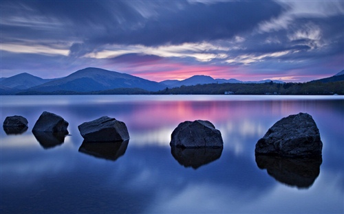
贵州地处云贵高原于东经103°36′~109°35′、24°37′~29°13间,东靠湖南邻广西,西毗云南,北连四川和重庆,东西长约595千米,南北相距约509千米。
全省国土总面积176167平方千米,占全国总面积的1.8%。
贵州地貌属于中国西部高原山地,境内地势西高东低,自中部向北、东、南三面倾斜,平均海拔在1100米左右。
贵州高原山地居多,素有“八山一水一分田”之说。
全省地貌可概括分为:高原山地、丘陵和盆地三种基本类型,其中92.5%的面积为山地和丘陵。
境内山脉众多,重峦叠峰,绵延纵横,山高谷深。
北部有大娄山,自西向东北斜贯北境,川黔要隘娄山关高 1444米;中南部苗岭横亘,主峰雷公山高2178米;东北境有武陵山,由湘蜿蜒入黔,主峰梵净山高2572米;西部高耸乌蒙山,属此山脉的赫章县珠市乡韭菜坪海拔2900.6米,为贵州境 内最高点。
而黔东南州的黎平县地坪乡水口河出省界处,海拔为147.8米,为境内最低点。
贵州岩溶地貌发育非常典型。
喀斯特(出露)面积109084平方千米,占全省国土总面积的61.9 %,境内岩溶分布范围广泛,形态类型齐全,地域分布明显,构成一种特殊的岩溶生态系统 。
贵州的气候温暖湿润,属亚热带湿润季风气候。
气温变化小,冬暖夏凉,气候宜人。
特别是气候独特的可处。
2002 年,省会贵阳市年平均气温为14.8℃,比上年提高0.3℃。
从全省看,通常最冷月(1月)平均 气温多在3℃~6℃,比同纬度其他地区高;最热月(7月)平均气温一般是22℃~25℃,为典型夏凉地区。
降水较多,雨季明显,阴天多,日照少。
2002年,9个市州地所在城市中,降水量最多是兴义市,为1480毫米;最少的是毕节市,为687.9毫米。
受季风影响降水多集中于夏季。
境内各地阴天日数一般超过150天,常年相对湿度在70%以上。
受大气环流及地形等影响,贵州气候呈多样性,“一山分四季,十里不同天”。
另外,气候不稳定,灾害性天气种类较多,干旱、秋风、凌冻、冰雹等频度大,对农业生产危害严重。
贵州土壤面积共159100平方千米,占全省土地面积的90.4%,土壤的地带性属中亚热带常绿阔叶林红壤—黄壤地带。
中部及东部广大地区为湿润性常绿阔叶林带,以黄壤为主;西南部为偏干性常绿阔叶林带,以红壤为主;西北部为具北亚热成分的常绿阔叶林带,多为黄棕壤 。
此外,还有受母岩制约的石灰土和紫色土、粗骨土、水稻土、棕壤、潮土、泥炭土、沼泽土、石炭土、石质土、山地草甸土、红粘土、新积土等土类。
对于农业生产而言,贵州土壤 资源数量明显不足,可用于农、林、牧业的土壤仅占全省总面积的83.7%。
贵州植被丰厚,具有明显的亚热带性质,组成种类繁多,区系成分复杂。
全省维管束植物( 不含苔藓植物)共有269科、1655属、6255种(变种)。
植物区系以热带及亚热带性质的地理成分占明显优势,如泛热带分布、热带亚洲分布、旧世界热带分布等地理成分占较大比重,温带性质的地理成分也不同程度存在。
此外,还有较多的中国特有成分。
由于特殊的地理位置,贵州植被类型多样,既有中国亚热带型的地带性植被常绿阔叶林,又有近热带性质的沟谷季雨林、山地季雨林;既有寒温性亚高山针叶林,又有暖性同地针叶林;既有大面积次生的 落叶阔叶林,又有分布极为局限的珍贵落叶林。
植被在空间分布上又表现出明显的过渡性,从而使各种植被类型在地理分布上相互重叠、错综,各种植被类型组合变得复杂多样。
贵州河流处在长江和珠江两大水系上游交错地带,有69个县属长江防护林保护区范围,是长江、珠江上游地区的重要生态屏障。
全省水系顺地势由西部、中部向北、东、南三面分流。
苗岭是长江和珠江两流域的分水岭,以北属长江流域,流域面积115747平方千米,占全省国土面积的65.7%,主要河流有乌江、赤水河、清水江、洪州河、舞阳河、锦江、松桃河、松坎河、牛栏江、横江等。
苗岭以南属珠江流域,流域面 积60420平方千米 ,占全省国土面积的34.3%,主要河流有南盘江、北盘江、红水河、都柳江、打狗河等。
由于特定的地理位置和复杂的地形地貌,使贵州的气候和生态条件复杂多样,立体农业特征明显,农业生产的地域性、区域性较强,适宜于进行农业的整体综合开发,适宜于发展特色农业。
求一篇介绍贵州的英语作文 最好有点地形介绍的 急需啊 高中水平 急需- -
Huangguoshu Waterall, is a national 5A level scenic area. Huangguoshu Waterall is located in Guizhou province Anshun city Zhenning Buyi and Miao Autonomous County Shuihe on white.Atlas surrounding the Huangguoshu Waterall karst wide cloth, the river water is urgent, mountains, magnificent momentum, all through the ages is connected with Yunnan, Guizhou two provinces in the main channel. White Shuihe flows through the river bed local time off the completion of nine waterfalls, the Huangguoshu Waterfalls is the largest one. To the huge water potential is one of the Great Falls, is also famous in the world. Falls across the built Guanbao Ting, visitors can enjoy surging in the booth vent rhino river rushing straight pool. Rose water is more than 90 meters high, in the vicinity of formation water, this summer, the entire heat dissipation. Behind the waterfall precipice recessed into a hole, called water curtain cave, the hole more than 20 meters deep, perennial waterfall hole cover, in the window of a glimpse of natural water. With its magnificent magnificent waterfall, waterfall group known serial with Yu Hai inside and outside, very splendid. And enjoy the China first waterfall of reputation, is in addition to Niagara and Vitoria falls outside of the third great falls. Huangguoshu Waterfalls scenic area is located in Guizhou West Tourism Center 45 kilometers southwest of Anshun City, Zhenning Buyi and Miao Autonomous County in Guizhou Province, northeast from Guiyang City 150 kilometers, Yunnan Guizhou railroad, six multiple track railway, 320 National Road, Huangguoshu Waterfalls airport, expensive ( Yang ) yellow ( fruit ) highway through the whole territory, new Qing ( town) yellow ( fruit ) high speed all the way to the scenic spot. Scenic spot to Huangguoshu Waterall as the center, with waterfalls, caves, subterranean Lake as the main body. The famous Huangguoshu Waterfalls falls, is the first attraction in Guizhou, China's largest waterfall, is the world's most Huangguoshu WaterallSpectacular waterfalls larger one. Within the scenic Huangguoshu Waterfalls falls as the center, the use of global satellite positioning system and other scientific instruments, measuring the largest waterfall in Asia -- Huangguoshu Waterfalls of the actual height of 77.8 meters, in which the main waterfall 67 meters high; waterfall 101 meters wide, of which the main waterfall top 83.3 meters wide. The distribution of male, odd, insurance, show different styles of the size of 18 falls, formed a huge waterfall family, by big world Guinness headquarters as the world 's largest waterfalls, included in the Guinness book of world records. Huangguoshu Waterfalls is a Huangguoshu Waterall in the most spectacular waterfall, is the world's only from the upper and lower, left, right, front, after the six ornamental waterfall, is the world with water curtain cave nature through and from inside and outside the tunnel, to view, touch waterfall. The Ming Dynasty great traveller Xu Xiake examines falls exclaim: ramming bead jade droplets collapse, back up, such as smoke vacated, potential very grand; the so-called ' bead curtain hook volume, hanging piece scouring remote peaks, all not enough to be the ' boy, Gao Jun has several times, but never this rich and big. In October 3, 2005, China's most beautiful places list released in Beijing. This activity by the China National Geographic host, the 34 media with the most beautiful places in China selection activity, which lasted 8 months, judge Academy of experts group, big media from the group and network mobile phone popularity group three categories of awards. Media group and popularity respectively in the media, mobile phone users to vote and the vote of each of the 12 winning local. By the China National Geographic magazine launched the thick and heavy in colours Academy of experts group award will have a style of one's own, into the mountain, lake, forest, grassland, desert, yadandemao, island, coast, waterfalls, glaciers, canyon, city, town, village tourist cave, 15 types of wetland. The selection of China's six most beautiful waterfall, Huangguoshu Waterfalls among them. Huangguoshu Waterall group is composed of 18 charm different size of the falls, of which Huangguoshu Waterfalls the most beautiful spectacular, it is referred to as the Huangguoshu Waterall group. Due to the falls Huangguoshu Waterall group not only unique style charm, very beautiful, can be called the world's most typical, the most spectacular waterfalls in Karst, and its surrounding has also developed a lot of Karst cave, cave development all sorts of Karst cave landscape, forming the famous Guizhou underground world, great tourism value, therefore, the State Council has approved the the Huangguoshu Waterall group listed as the first batch of key scenic area. Can foreknow, some time after, with the further development of Huangguoshu Waterall group, Guizhou South Africa will become our country and even the world's most famous waterfall scenic area of.我英语,哪的自行修改一下。
贵州省主要地形类似于
高山。
丘陵 贵州地貌属于中国西部高原山地,境内地势西高东低,自中部向北、东、南三面倾斜,平均海拔在1100米左右。
贵州高原山地居多,素有“八山一水一分田”之说。
全省地貌可概括分为:高原山地、丘陵和盆地三种基本类型,其中92.5%的面积为山地和丘陵